Fuerteventura is the last of the Canary Islands on my list to do the cross island GR131 trail. I did my homework, and most hikers who blog about the route detested significant chunks of this walk – as it goes on tarmac through resorts. Doing a bit more homework yielded some excellent alternative routes around the mountains so I came up with a route that joined the parts of the GR131 I wanted to do and some excellent side hikes. The original route was 150km, mine was 130km but with a lot more ascent
Accommodation in the mountains is a bit tricky, and there is a network of trail shelters in which it is illegal but tolerated to camp, as the locals understand it is impossible to hike across the island without having to wild camp somewhere.
Day 1 – tour of Mt Cardon and then onward to Pajara (18km and 800m of ascent)

I stayed at the premier inn at Gatwick as there is nothing worse than a 4am wake up call. At 5.45 I woke up, had my coffee and breakfast in hand after security at 6.15 and was in the lounge at 6.30 ready to board the 7.15 flight. I was even organised enough to fill up all my water bottles at Gatwick after security. The flight was packed with British package tourists like normal and I suspected I was the only one who didn’t have any accommodation booked for the duration of my stay and was planning on bivouacking where I could
On landing, my only shopping requirement was to get some fuel for my stove (I bought an alcohol stove as there are few stockists of gas canisters on the island), so I got my taxi to stop at the hardware store to buy ‘alcohol de quemar’ and I was set
The nice taxi driver dropped me 50 km from the airport in a deserted parking area near mt Cardon and asked me if I was sure….. and was surprised when I told him I was planning to walk more than 150km to corralejo.
The 7km return trip up the mountain was delightful, with nice views down to La Pared and the ocean. The mountain is a pilgrim route with a lovely cave church at the top.
I returned to Cardon ‘town’ after the mountain hoping the bar I had passed would still be open at 2.30. Alas it was not to be – so no lunch apart from a protein bar, and some rationing required on the water to last until the next morning
The 3km after Cardon seemed very hard – it was hot, the wind had dropped, so I was sweaty, thirsty and hungry as I climbed a steep hill. I stopped near Morro de Moralito at 420m for a coffee and a protein bar and stuck my sun hat on
After that the trail did take a while, but it was mostly easy walking, albeit with quite a lot of ascent and descent rolling along the ridgelines. The views out to both sides of the island were spectacular.
The sun started to noticeably drop at 5pm so I hoped I would make a good campsite by nightfall. There weren’t obvious pitches en route and I knew there was a shelter near Pajara – which would have the bonus of a table so I could cook sitting up (handy with an alcohol stove) and sleep out of the wind
I got to the shelter at 6pm and it was situated on a gravel road I had seen three cars drive down and it was only 1.5km from Pajara – so hardly off the beaten track. However I would be entirely hidden from view sleeping on the bench behind the big stone table and it was wonderfully sheltered. I needed the shelter as the winds were 30kph and it would be a bugger to pitch a tent. I reckon I ruined one hikers day though – as a young guy strolled to the shelter with a full pack and a bag of food, clearly hoping to stay, and he kept walking when he saw me (thank goodness, I don’t like strangers).
I had a lovely beef stew for dinner, a lot of rehydration salts and a hot chocolate and hit the hay at 7pm. Or I tried to. I couldn’t quite get comfy but I reckon I finally fell asleep at 10pm. Amusingly the rubbish bin in the shelter which I was happy to see (saves carrying rubbish), seemed like less of a good idea during the night as the loud rustling from said bin confirmed the existence of a rat or a mouse – but I wasn’t inclined the leave my sleeping bag to check. The stars were lovely and it is quite nice sleeping in the open air, although with 35k winds I was pretty happy to have the thick rock walls of the open sided shelter keeping the worst of the wind away


Day 2 to Degollada Marrubio via Ermita de Penitas and Gran Montana (28km and 1700m ascent)

I was awake at 6, but as the sun doesn’t come up until 7.35, I made a coffee and read the newspapers on my phone in my sleeping bag. I was surprised by a passerby and his dog out for a stroll around 7am – they didn’t see me fortunately as no doubt they weren’t expecting to.
I packed up my bed roll, finished my muesli and headed into Pajara, hoping that somewhere would be open to buy water. Fortune smiled on me and a tiny shop was open. And then I got even luckier as one of the cafes was open for coffee – and full of old Spanish men chatting with vim and vigour at 7.45 on a Sunday morning
From Pajara it was a couple of km gentle stroll along a dry river bed then a lovely manageable climb up through agave and tabaibal to the Degollada los Granadillos. The winds were fierce (40km an hour) and heading towards me verses aiding me up the mountain but it was still a nice walk. After the pass (degollada), it was an easy meander down to Vega de los Palmas, where I did a detour off the GR131 to head down to the Ermita de los Penitas (a worthy 3.5km detour). The damn was lovely and the views down the ravine to the tiny church were gorgeous.
After that I was in need of sustenance and more water. The first three establishments I passed were all closed, so I was delighted to see the Don Antonio open. The fed me like royalty and let me charge my battery – heaven
After lunch I took another detour off the trail – 7km and 500m of ascent to climb Gran Montana at 670m for fantastic 360 views across the island. The trail was straight up but I didn’t go too fast as I had a full tummy from lunch
The route detoured back close to Vega where I rejoined the GR131 and headed towards betancuria – stopping for a cup of tea at the sheltered and deserted Castillo de Lara (a recr
After that it was a hard grunt up to the degollada de marubio at 60where there was a trail shelter that was home for the night. The wind was up and the roof was made of branches, so I tried to see if I could get my tent up within the confines of the shelter for more cover but there was no room and the picnic tables were fixed firmly to the ground. And it was too windy to pitch outside. So I did what previous hikers had done and slept on the picnic table after a dinner of soup and a hot chocolate.
I prepared for a windy night – put my dry night clothes on, made sure the quilt was well secured to the Therm-a-Rest and slept with hat, gloves and my down jacket. What I wasn’t prepared for was lifting my head in the middle of the night and the pillow blowing down the mountain. I was well secured in the quilt so it took me a moment to get out of bed and start chasing. The pillow was restored and I weighted it down by putting it in a dry bag with my clothes to keep it from blowing away again


Day 3 to Sargento 29k and 975m of ascent

I woke up at 6 and stayed in my sleeping bag until the caffeine cravings forced me to move. After breakfast of muesli, I headed down the hill to the village of Betancuria. It is clearly a village for day trippers as there were tonnes of restaurants (all closed at 7.45 this Monday morning) and no hotels. With no coffee in sight, I continued up over the pass at Corral De Guise (past a bizarre statue) and down to Valle de St Innes to pick up supplies and have two excellent cafe con leches
From St Ines it was a hot flat walk through Llanos all the way to Tefia – mostly on roads. Not my favourite walking but at least there were few cars. I stopped at 11.30 for lunch after 15km at the trail shelter under the lovely Mt Bermeja – the highlight of the morning
Then it was a more entertaining 9km walk through Tefia to the town to Casillas de Angelos (a gr131 detour), which had nicer views back to the mountain ridge line I had left this morning
I arrived at Casillas at 13.35 to find all the restaurants closed and the minimart had shut at 13.30 and wouldn’t reopen until 6pm. Fortunately there was a gas station so I bought more water and had an icecrean
Leaving Casillas I headed up a grey rocky hill side with steep steps and rubbly ground to reach the degollada de La sargenta at 479m which had lovely views out of Tetir and a nice view of the trail shelter which was my home for the night 200m below
I arrived at the shelter earlier than I normally stop – at 4pm – but with the wind forecast I decided to stay here for the night as the next shelter was 20k away. I dried my sweaty clothes in the sun and pitched my tent (there was room in this shelter). I typically only pitch my tent 20 mins before sunset in case of passerbys (wild camping is illegal in Spain although tolerated apparently in some places). I didn’t think I would be disturbed so pitched at 5pm and then was promptly surprised by two trail runners charging by. I suspected they wouldn’t call the rangers on me, and was right, I had a very peaceful night with my head down by 8pm (which did lead to a 4am wake up but no matter)


Day 4 to La Oliva 31k and 1300m of ascent

After the 4am wake up and two coffees, I was packed and ready to go at the first inkling of light. It was a lovely stroll up the valley passing over the degollada de facay and then a good mountain path back down to tefia. Sadly I was too early for the cafe so I kept going to the village of La Matilla – where the cafe was also closed. I was fantasising about a bocadillo.
I kept going to Vallebron over an excellent rugged pass where the winds were so strong I was getting buffeted sideways but I managed to keep my feet and eventually made it down to Vallebron where the only shop was also closed
It was another 6k to Tindaya and the winds were howling and the air was very hazy (normally it is dust coming in the storms from Africa), and I was super excited after 22km to make it to bar Maria at noon for two Coke zeros, a large bottle of fizzy water, an omelette sandwich and some chicken wings (they had a very limited menu).
I headed back out into the storm and had hoped to climb Mt Tindaya but the sign said the path was closed. So I continued the 8km to La Oliva, walking on a sideways slant to the wind, keeping my glasses on to keep the dust out, and trying to keep my spirits up by singing cheesy songs at loud volume (no one can hear you in the wind, and I hadn’t seen anyone on the trails for days).
I finally made it to La oliva around 2.30 and decided to find a b&b as pitching a tent in the winds would have been near impossible. There was nothing available in town so I hopped on the hourly bus for the 30min ride to Corralejo and stayed at a package tour hotel (full of pensioners sitting on their balconies drinking and doing crosswords). The bath was excellent and I managed to get some fresh vegetables and fish from the local supermarket. All clean and I had a good night sleep (once I put ear plugs in to drown out the loud British teenagers next door)


Day 5 La oliva to Corralejo – 23km and 850m ascent
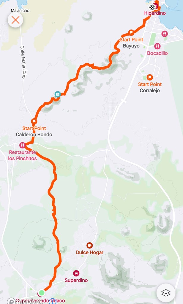
I was up early so rather than wait for the bus I took a cab back to La oliva and started walking. The ‘badlands’ or ‘mal pais’ area was stunning in the morning light and there were lots of good camp spots if I ever come back
I got to Lajares in under two hours and it was a bizarre surfer hippy town but not on a beach. I detoured off route for an excellent coffee and sat and listened tot wh aging French hippies around me complain about covid
Heading out of town I took the choice to detour off route to visit the Calderon hondo (a huge crater). The winds were up and there were moments as I walked around the crater that I was buffeted sideways and I wondered how embarrassed I would be if Canarian mountain rescue had to come bail me out if I fell in. This are always quite busy – the first time I had seen any people on the trails for days (the only time since ermita las penitas). It was worth the detour
From there the trail was essentially a flat gravel road into Corralejo, so I took another detour to go up Bayuyo (278m) which had stunning views down to the sea, but there were moments were I was less than comfortable on the ridge line with the high winds.
I stumbled down the hill hanging on to the sides to rejoin the gravel road. From there it was an uneventful few kilometres to town. I went to the beach to do my customary feet dip in the sea, to find a sign advising against bathing due to water contamination – blech. Instead I made do with rinsing my toes under the public shower (if there had been less of a crowd I might have had an actual shower)
I had a yummy lunch of squid, canary potatoes and melon, and then as I had time to kill took the bus to the airport (I do quite like buses, there are always interesting people on them). While not my favourite hike of the canaries it was worth doing. Taking the late flight back to Luton and then to work in the morning


Puerto del Rosario, February 9, 2022
Additional notes
The government has an excellent website that has maps gpx and trail notes to download. They have the shelters marked on each of the maps. I also used the cicerone guide to walking in Lanzarote and Fuerteventura.
You must be logged in to post a comment.