I am still injured (Achilles is quite broken) so I am not going anywhere very fast, but I managed to squeeze in a few days hiking late last year after lock down rules eased up and took advantage of the travel corridor from the canaries heading back to the UK.
It was a goal of 2020 to finish the GR131 cross island trails on all seven of the Canary Islands. At the beginning of 2020 I managed to complete the GR131 on Tenerife, Lanzarote and La Palma. And then things got busy. But now, I am headed to La Gomera. There are no direct flights, but a plane, bus (a short break for steamed clams and salad on the beach) and a ferry ride later and I made it to San Sebastian – the capital of La Gomera. I have a bit more time than normal so am going to walk all of the GR131 and most of the GR132 in a loop, starting with the GR132.

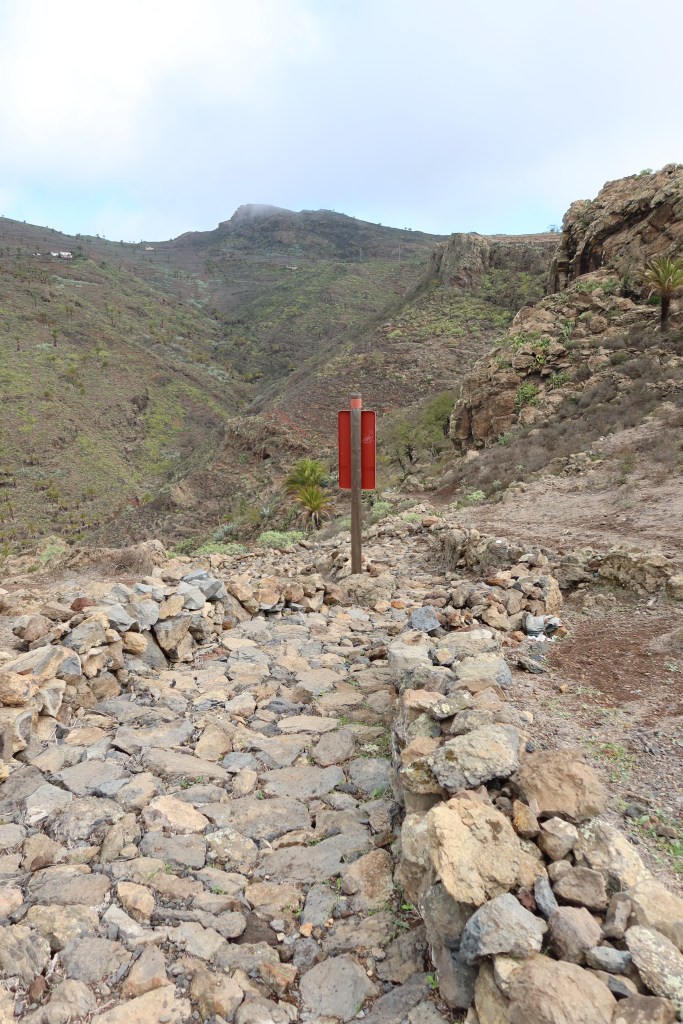
Stage 1 San Sebastian to Playa de Santiago (20km, 1050m ascent)
I left San Sebastián on a quiet morning and headed up the hill. The trail was relatively straightforward after getting out of the run down industrial estate. The light was lovely and there were fleeting glimpses of Tiede through the clouds.


I love the flora on the Canaries. The contrast of the volcanic ash, spiky baranchos and excellent trees (which are not actually dead, but often look it)

After meandering for about 5k, there was a steep downhill to Playa de la Guancha and then an excellent stroll up the Barranco de la Guancha on the other side


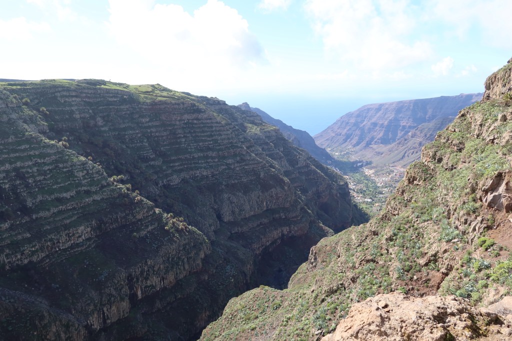
After la Guancha, there was short steep climb to a ridge in between the two Barrancos – Guancha and Cabrito – with excellent views up into the mountains in central La Gomera


Fortunately the hotel in El Cabrito was open, so I managed to get a diet coke. After El Cabrito it was a relatively tough 500m climb up to Morales, made tougher by recent rain which made the clay underfoot really gluggy. By the time I got up to the top I was pretty sure I had an extra kilo of mud on each foot. But the weather was good, and there was noone on the trails,so it was a blissful afternoon. In 6.5 hours I only saw 6 other people (two solo guys hiking, and two pairs of guys hiking).


After Morales there were two drops down into Playa del Medio and Barranco Chinguarame

I arrived in Playa Santiago around 4pm and had to don a mask (it’s compulsory to wear a mask everywhere in the Canaries, but I decided to to skip it while sweating and hiking for 6 hours without seeing anyone). I found a nice hotel and then spent a lazy afternoon reading a book and an early night
Stage 2 Playa de Santiago to La Dama (24km, 1320m ascent descent)
I got up when the sun came up and headed out of town around 8am and town as deserted.

After passing through town there was a long slog up a jeep track to climb 800m and 11km to Alajero. Normally I hate jeep track, but actually it was probably what my heel needed. The views weren’t terrific but there were some nice views over Barranco Santiago and the Rocas de Los Moros near Targa were nice


I arrived in Alojero around 11am and was starving. The first restaurant I passed was closed, but the kiosk was open so I had two coke zeros, one cafe con leche and a ham and cheese sandwich

I wandered off down the hill after lunch and was gleefully singing loudly and out of tune when a sprightly German guy passed me (awkward!). He was one of only two hikers i saw all day. The section between Alojera and Arguayoda was exceptional traversing two stunning and steep barrancos – Charco Hondo and Negra.


A couple of hours later I popped out on the road to Arguayoda and the heat was shimmering off the tarmac. It was a rocky and rough dirt track down to the top of Barranco de Erque. From there it was a tough and rocky 300m descent followed swiftly but a touch and rocky and very sweaty ascent up to La Dama. I was ready to stop when I got there as my feet aren’t exactly accustomed to the hiking these day.


I took a taxi up to chipude as there are no hotels in La Dama, and nursed my blisters in the Bar Sonia
Stage 3 La Dama to La Calera (16km 1000m, ascent)
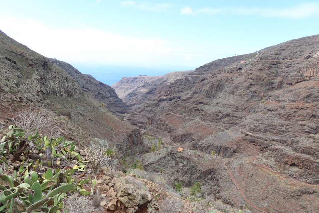
I got a taxi back the trail head early in the morning. Leaving La Dama it was a pretty unsalubrious industrial jeep track down to the Barranco Samarardon, which quickly opened up into stunning views of the Playa de Iguala and some excellent ridged terraces. The path descends all the way down to the bay, and you have to pick your way across the barranco to do the steep hike up to Punta de Iguala on the other side


The rain was consistently reliable. It would come in sheets for about 5 minutes, taking me at least the first two minutes to get my poncho on. Then I would eventually get too hot and take my poncho off and the rain would reliably show up about five minutes later. There were stunning views along the ridge down into the barranco Samarardon – walking up first half of the 600m climb to Gerian. The views weren’t quite enough to distract me from the weight of the clay on my shoes. It was a feat of glugginess. Eventually the weight of the mud would get so heavy it would start to fall off in clumps (I reckon this was at about 1 kilo of mud per foot). However the clumps were pretty uneven so my footing wasn’t particularly stable. It was ok, if tiring, for much of the path, but when the ridge line switched to look down over the Barranco de Argaga, I was a bit worried about a clay induced tumble over the cliff side… the path was alongside a pretty sheer drop. The views were stunning though, down to Argaga beach, and the scene looked like the grand canyon with the red peak of Tergerguenche protecting the bay


At the top of the hill I passed by the tiny Ermita de Guadalupe, which was a little white church which seemed strangely out of place at the top of a high peak


Stunning descent to the Barranco de Argaga – a riot of cactus and palm trees and colour – topping out at the narrow ridge of Degollada del Cerrillal before a technical and knee busting descent down to La Calera.


It was another excellent day of hiking, and I only saw two German couples the entire 16km from La Dama to La Calera. Bliss!

Degollada del Cerrillal

I took the guagua (local 18 person bus) back to Chipude. I was grateful everyone had to wear masks as I was a bit whiffy.
Stage 4 Arure to Vallehermoso (15km 630m ascent/1250m descent)
I had to put my big girl pants on this morning. The first part of the hike was a wonderful balcony walk along a steep cliff face from Arure down to Alojera. I have vertigo at the best of times and am really not very sure footed (hence the odd broken bone from out hiking). I am even less sure footed right now, as it is a bit like playing roulette when I land on my left foot, I am never sure what the Achilles is going to do. The balcony path was stunning but vertiginous and slippery… and I had to give myself several talkings to to keep moving, it took a full hour to cover the first 2 km, but at least I stayed up right and my fears of tumbling down the cliff side didn’t eventuate.


I enjoyed the views and then stopped in Alojera for a coffee at the Bar Pompero. Mask wearing is mandatory everywhere in Spain, even outside, but adherence is fairly loose in the small mountain villages. Most people are wearing masks, but they are often chin warmers. Though if they see newcomers then tend to hoist them up a bit to cover their mouths if not their noses.
After coffee, it was a wet, slippery and soggy slog up a steep hill to get to Chorros de Epinas. The track intersected the highway several times but i only saw two cars. The track eventually entered the forest, and it seemed quite surreal after three days of dry hillsides with the odd cactus and palm tree to be in very damp forest with abundant lichen. I was looking pretty fetching in my rain poncho, the best investment I have ever made (keeps my top half, my legs and my pack dry)


I arrived at the top of the hill quite sodden and asked if the restaurant at Chorros served food. Sadly it was too early for lunch, so I was forced to have the excellent pear cake for sustenance instead

The weather continued to be fickle and it went from sodden to steaming every five minutes. It was a lovely stroll down an excellent path down the vallehermoso, in spite of the rain, it was the most gentle descent to date. Unsurprisingly given it was a gentle path, I fell on my butt three times.

Not far from the end, after ten minutes of torrential rain, the sun came out so I sat on a rock and sunned myself. These lazy days of hiking are actually quite nice.


I eventually wandered down to Vallehermoso bought some supplies and then a got a taxi back up the hill to Chipude with a young man who didn’t value his life or have any sense of appropriate following distances….. it was a bit of a hairy ride given the windiness of the roads up here. Safely home and time for a wee lie down and a bit of book reading before another hearty dinner at Sonia’s Bar.
Stage 5, Vallehermosa to Chipude (14.5km 1300m ascent/340m descent)
It took 45 minutes to drive the long and windy route back down to Vallehermoso this morning, fortunately with a much better driver than yesterday. Chipude was misty and wet, but we broke through to the sun about half way down the hill. The route today is pretty much a constant uphill for 7km and then a nice 7km winding between mountain villages.


The sun was shining, I had some epic tunes on, and in spite of some problems with the Achilles on the left and a bloody (literally) blister on the right heel, I made slow and steady progress to the top stopping for morning tea in a sunny spot about half way up. The route climbs up the spine of the mountain ridges with epic views back down to Vallehermoso and the Roque Cano


Quite close to the top of the climb the trail enters into the Parque Garajonay and it is like being transported to an ancient woodland realm of the elves. The Lauresilva trees were lovely with the sun dappling through.


From Le Creces it was an easy stroll to Les Hayes were I stopped for lunch. No sandwiches on offer today so I had goat and yams – which were pretty good, and enjoyed the sun on the terrace for a while


After that it was an easy meandering walk through El Cercado and on to Chipude with some lovely detours to the Barrancos. All in, it was the easiest day so far in spite of the elevation, and only took four hours. Am sitting with feet up enjoying the view of La Forteleza and having a well deserved copa de cava


Stage 6, Chipude to Degollada de Peraza (16 km, 1200m ascent)
Unfortunately three work conference calls meant a late start this morning, meaning I would have to skip the final 8-10km descent into St Sebastian unless I fancied doing it with a headtorch – not really as apparently it was rocky and rugged. Oh well, the best half of the walk was the first part of the stage, so work finished, I headed off around 10.45.


I had hoped that by leaving late the highland mist would have cleared and I would have some views, but it was not to be. So most of the morning and early afternoon was strolling in the mist. I am sure the views were stupendous but I couldnt see much


The trail meandered through Pavon and Igualera and then followed a series of ridgelines with viewpoints in different places (without much of a view) including up to Alto de Garajonay (the highest point on La Gomera)

At around noon the rain started bucketing down and I embraced my poncho (I love my poncho). I kinda liked the hiking, it reminded me of home. The trail was muddy and rooty. My feet were soaking wet. Actually I was entirely soaking wet. Combined with the ferns and the trees, it felt just like hiking in New Zealand
By the time I reached the Roque de Zarcita and the Roque de Agando the mist relented slightly for about two minutes and I managed to get a little view.


I made it to the Degollada de Peraza around 3pm, which would have had stunning views down into the Barrancos. There is a nice symmetry in hiking this high up in the hills after traversing the barrancos closer to the coast

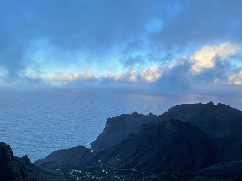
I arrived soaking wet at the Degollada and waited for the Guagua which eventually came around 3.40 to drop me back into San Sebastian. I then hiked up the hill to the Parador, warmed myself up with a very long shower and treated myself to a nice dinner


While probably the easiest hike I have done for a long time in terms of distance and elevation, it was a big milestone for me to get through it given I haven’t been able to hike for a long time (or run for over four months). My feet are battered as I have had to learn how to hike differently (using my heels as well as my toes) and in more supportive shoes (annoying high drop cushioned shoes rather than my prefered zero drop grippy runners). I haven’t had this many blisters for a long time.
Additional notes
- Fly to Tenerife south, bus to the port at Los Cristianos (titsa) and take the Fred olsen ferry to La Gomera (50 mins, 3 times per day)
- Best book was the cicerone guide and I used the gpx files and uploaded them to my gaia account. Other gpx files are on here
- Accommodation was a bit tricky as with covid many locations were closed. Having figured out the road system, I rented an apartment in Chipude for four nights and went back and forth for the last few sections
- Getting around was easy with either the Gomera bus or I cabbed from Chipude (€20-25 for most destinations from Chipude)
- I started and finished in San Sebastian de la Gomera and stayed at the lovely Parador La Gomera, where the restaurant is excellent
You must be logged in to post a comment.