I have been loving the high altitude treks in the Himalayas, and have a few weeks free so am heading to Northern Peru to hike the Alpamayo and the Cordillera Huayhuash (pronounced Why wash) treks. The guidebooks say each trek takes 10 days with mules and porters, so I have planned to do each in five days and carry my own food and gear. Lets see how it goes… (Note this is a very hiker oriented post, so if tents and mountains bore you…… definitely time to click on :-))
Described as a tough circuit for experienced mountain hikers, the Alpamayo is a 120-140km circuit circumnavigating the mountain passes around the beautiful Nevado Alpamayo (5947m). I will start at Cashapampa and finish at Hualcallan, scaling a lot of high passes in between. The map below shows the route (map from the Quechandes trekking website). Most nights I will be above 4000m where temperatures will almost certainly be below zero, so I am packing a heavy sleeping bag (good down to minus 20 celcius), down pants, down slippers, a well insulated sleeping matt and my new tarptent stratosphire li (which is a little bit warmer than my beloved Duplex tent). One of the reasons for covering both routes in five days is that it never really takes me that long to cover the distance (20-25km per day on my 5 day itinerary), AND it is a hell of a lot easier to carry five days food than ten days food. With 6 days of food (one day extra for emergencies) and very warm gear, I am at 16kg of weight without water, which hopefully will be available frequently. The food weight is probably about 4-5kg, so at least it will get lighter as I go and I eat it.

My starting point was Huaraz (accessed by bus 8 hours from Lima), a bustling mountain town, where I planned to stay four nights to acclimatise. Most of the hikes get to 4000m very quickly and have multiple 5000m plus passes so acclimatising is key. Lima is at sea level, Huaraz is at 3000m. I have learnt the hard way not to rush it. I could feel the headache hit me as the bus went over the 4100m pass on the way to Huaraz and then I struggled to get up the stairs carrying my 24kg duffle when I arrived at the hostel. I had intentionally decided to do naff all on day 1 apart from some errands. I sorted a sim card (see below), bought some food to make breakfasts, got gas for my stove, had a steak and enjoyed the sun shine and reminisced about Peru (I hadn’t been for 24 years, and met my husband last time I was here)
Acclimatisation hike 1 to Wilcacocha at 3700m, 700m of ascent 8km
I had loads of time, so wandered to the market to take the collectivo to the trail head (2 soles/40p) rather than take a cab. Collectivos are as rammed as london rush hour tube, but better you can tell them exactly where you want them to stop. I was anticipating a bit of breathlessness, but I made the 3km hike with 600m of ascent in an hour and ten minutes, just taking it slow and keeping my heartbeat below 130. The trail was well marked and well populated with kids and donkeys descending to town. I arrived at the village of Wilcacocha to the sight of the whole village tidying the path (tree cutting, drain digging and rock moving). The laguna at the top isn’t amazing but the views were pretty delightful. Rather than go back the way I came, I guessed at a route that would come out at a bridge closer to Huaraz where I could take a collectivo back. The route was lovely, and I did manage to tumble on a rock and have a huge bruise on my shin when I was distracted by the view. I passed more villagers cleaning, and a couple of the old men shook my hand. I found my way the 3km back to the road and took a collectivo back to town and arrived at 11.30am. Another lazy afternoon, I tried the local curry house (bad idea), bought more supplies and chilled out).


Acclimatisation hike 2 to Laguna Churup at 4550m –
I arrived at 6.50am for the 7am collectivo (minibus) to the trail head at Pitec (10 soles each way) which of course left about 7.50am when there were enough gringos for it to leave. We arrived at the trail head at 8.45am and 3850m for quite a high start. I took it easy up the trail, never stopping for a break, but keeping my heart rate below 130 the whole way – much better for the acclimatisation. It took an hour and ten minutes to get to the lagoon, most of it on very easy trail, but the last 20 minutes was a scramble/rock climb up a chained section that made me grateful I had been working on my pull ups. The view was spectacular, and I had a chat with the young men who had hiked up with me (everyone here is pretty much 23 years old). I had breakfast and then lost feeling in my fingers so decided to wander back down the hill. I went the less scrambly long way back down for a different view. It was a spectacular day, and then wandered to the market with my new friend Andrea for an outstanding pork sandwich. Feeling surprisingly good given this is the highest I have been for a few years – no headache, no dizziness, and slow but feeling fine.


Acclimatisation Hike 3 – Laguna 69 to 4750m (hiked en route to the start of the Alpamayo Circuit
The joy of being a midlife flashpacker is that I really enjoy staying in hostels (I am at the El jacal backpacker which is a costly usd 91 in total for four nights in a room with private bath and a balcony), but feel fine spending money on things which increase my time spent enjoying stuff. Today that translated in hiring a driver to take me first to do an excellent acclimatisation hike to Laguna 69, keeping my 16kg bag in his car, and then driving me up to Cashapampa to start the Alpamayo circuit. Saved me about two half days of driving and collectivos
The hike to Laguna 69 was lovely. I was worried it would be overcrowded. But while we left Huaraz at the same time as the guided tours, those inevitably stop for breaks. We arrived first and on the two hour gentle walk up the 700m ascent to 4600m I only passed one very friendly Peruvian family. The path was excellent and I was feeling good. I stopped at the top for some salami and an apple (the best picnic I found and then wandered back down passing about 60 very red faced tired people and about 4 fit hikers (I passed them first as they were racing to the top). I got back to the van in four hours, at 11.45 and we bumped back down the gravel road to Yungay and then headed up to Cashapampa to start to alpamayo trail


Alpamayo Circuit – Day 0 – 5.5km*, 706m ascent
Cashapampa was down at 3000m so 1000m lower than where my morning hike started today. This meant it was easier to breathe but it also meant it was hotter. I had originally intended to stay the night here and start in the morning but the accommodation choices were grim. So, I left the pueblo at 2.30, and grunted and sweated up the path, now carrying 16kg of gear, only planning to walk far enough to pitch the tent. I always have an hour on the first day when I wonder WTAF am I doing, and I definitely had it today. It’s been a while since I have carried a pack this heavy but at least it will get lighter as I eat the food. And given how cold it was at 4000m this morning when I was hiking I think I will be grateful for the gear.
I wasn’t planning to hike far, just as well, it took me 2 hours to do about 5.5km, which was when I found the first obvious flat spot to pitch with river access. Most of the way up the steep quebrada, the river was far below and a tough scramble to access. I arrived at 4.30, made lunch/dinner, had two teas and a cocoa, and got into bed at 6pm as darkness fell listening to the river rustle by. My favourite thing about my new gear is when I stuck my feet in my sleeping bag it was like putting them in front of the fire. Amazing. I woke up twice to pee and the moon was in full beam, enough to make the donkeys eyes light up watching me do my evening ablutions


Alpamayo Circuit – Day 1 – 27km*, 1313m ascent to Taulipampa via Alpamayo base camp and Laguna Huayracocha – cold and breathless
I was awake at 4.45 so made some coffee and stayed in my sleeping bag until about 5.15 when I packed up and headed out, walking by 5.45. I needed a head torch for the first ten minutes but after that the sun started rising.
I walked about an hour and a half to Llamacorral campsite – my idea of hell – a campsite with a group of 11 hikers and their crew of 20 plus mules and horses. I did pick up three adorable dogs here who escorted me for a few hours. By 9am I was getting hungry so stopped for brunch next to a lovely stream (with the optimistic dog waiting for food). The trail was ‘easy’ but walking with 16kg is always tiring. The scenery is lovely and the flowers wonderful, this whole stretch reminded me of the Rees and the Dart valleys in NZ
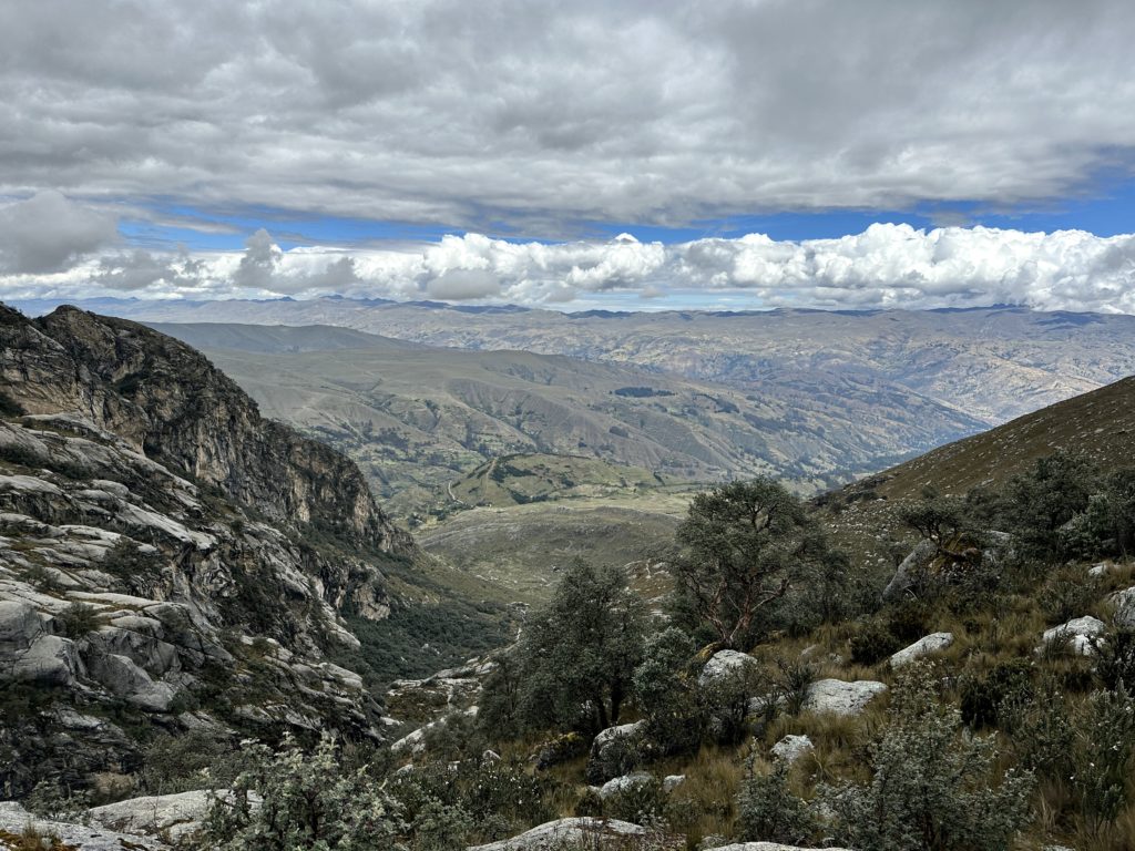
Around 11 I reached the end of the river valley and decided to take the 10km side trip to see if there was a view of Alpamayo and to visit Laguna Huayracocha. It was raining so I wasn’t optimistic. This was the beginning of two grunty uphills of the day – neither terribly difficult but tough at 4000m, in the rain and slogging a pack. The view was worth it, but it was cold and raining, and I had to put on all my layers and gloves and it still took me a while to regain feeling in my fingers
Descending was slippery and cold but the sun came out as I returned to the main trail to Taulipampa. I arrived at Taulipampa at 2.45 and decided to stop for the day as didn’t want to push camping at too high an altitude (plus I was pretty knackered). The sun was shining and for brief moments when the wind wasn’t blowing it was lovely and warm.
Dinner was beef stew, some nuts, lots of tea and some dark chocolate. Am not that hungry but what I eat doesn’t have to be carried in the pack!
My gear is working well. Having a new double walled tent (tarptent stratosphere li) is lovely as there is no condensation and also the ‘solid’ (but extremely light inner wall blocks the wind more than my duplex’s mesh). The very heavy sleeping bag from Rab is worth the 1.2kg weight as it is so wonderfully warm. And for the first time in years I am hiking with a proper goretex parka (in Europe I never take anything more than an ultralight waterproof), and it earned its money to day as well keeping me bone dry and warm enough in the rain and hail.


Alpamayo Circuit Day 2, 25 knackering kilometres* with 1751m of ascent taking an astonishing 11 hours (including breaks)
I didn’t sleep well, woke up at 3am with a big headache – not really surprising given I am sleeping at 4250m so I popped a Diamox and an ibuprofen and tried to get a few more winks.
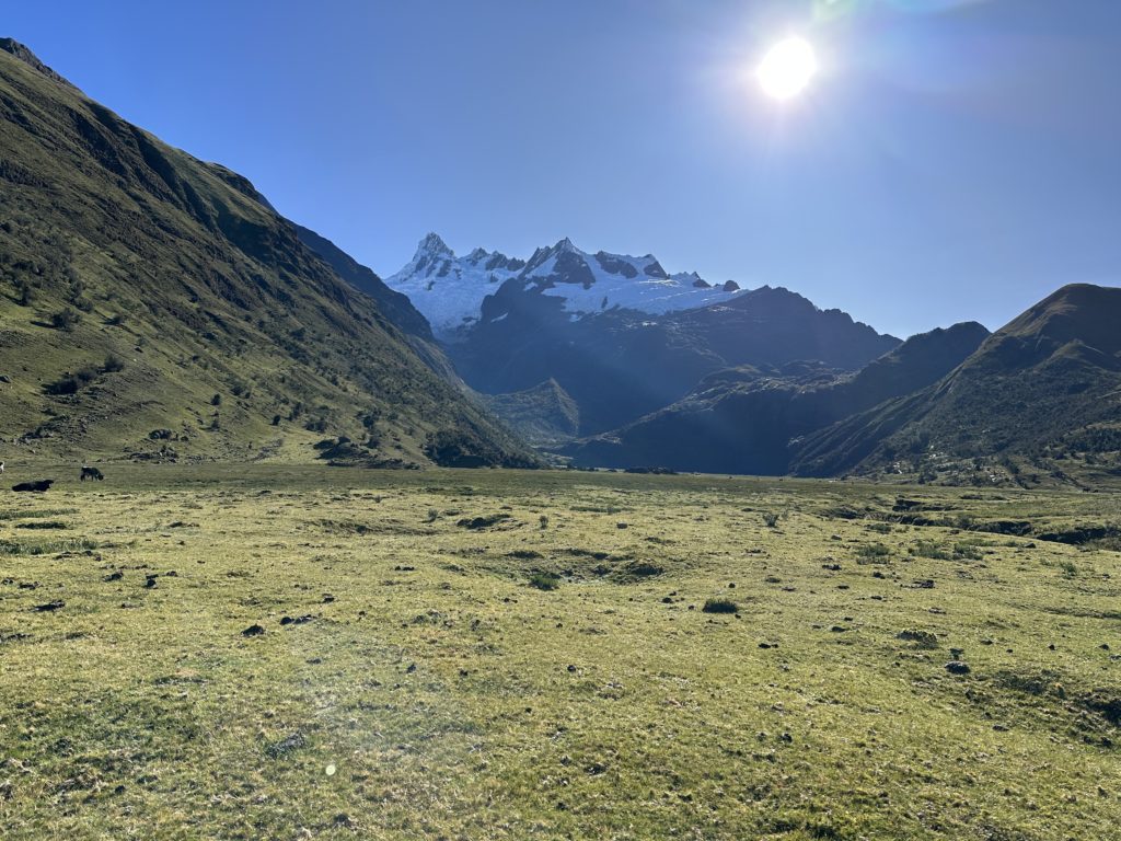
The morning got off the a punchy start at 6.15am with a 500m ascent (I counted 40 switch backs) up to 4750m punta union pass. The view was stunning if freezing. I could see roughly where the next pass I had to go over but it looked like an impossible wall of sheer mountains…. hmmm, yup another wtf moment.
The descent down the other side was swift and sunny, and I saw some young British kids I had met in Huaraz and a few other hikers as this section is part of the more popular Santa Cruz trek. I left the main Santa cruz trail around 9am and descended all the way down to 3900 m in a valley then stopped for brunch and more coffee to brace myself for another big pass
It was a hot and sweaty 59 switchbacks and 400m of ascent up to Pucaraja pass. Normally I would have that done both of those climbs in the Pyrenees before 9am without much of a sweat but climbing is brutal at altitude and with a full pack. I didn’t get to the top of Pucaraja until noon. And I was beat!
The meander I was expecting down the Wicrococha lake didn’t turn out that easy, and when I got there at 2pm I had walked a total of 15.5 km (ie nothing). I am British now so I had a cup of tea and reminded myself I can do anything, and found the resolve and my big girl pants to do the last 10k up the river valley. It was a moment
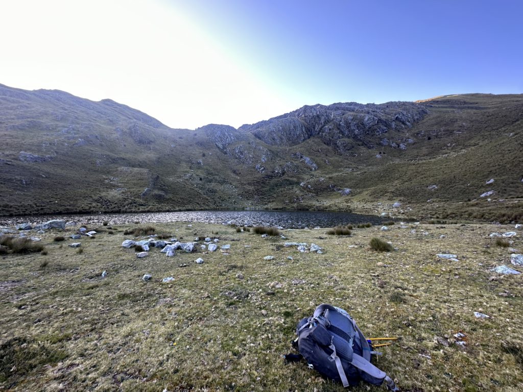
About 7.5km of the river valley was fine if a bit boggy. Then I had to cross a freezing river up to thigh deep and bush bash up 300m of vertical to the lake I had planned to spend the night (the trail didn’t exist where the GPS said it was). I arrived at 5pm, the sun had gone behind the hill, I was cold and knackered. But I was hopeful that every tough day is making me fitter. Camp was set up super quick, three more cups of tea, dinner, muesli and a hot chocolate and in bed by 7pm. It was one of the toughest days I have had in the mountains in a long time, but proud I made it.


Alpamayo Circuit Day 3 – 23k* to near Huilca with 1536m ascent with lots of local entertainment
I woke up at five with ice inside my tent, on the outside of my (very toasty inside) sleeping bag, and socks and shoes that were frozen stiff. Oh well.
I made two coffees, packed up (I cunningly pack everything without ever exiting the tent, apart from breaking the tent down when I get out) Stuffing my massive sleeping bag into a compression sack and decompressing the thermarest to help to warm me up a bit more .
First up a gentle 150m ascent to the pass above where I camped, then it was a 7km rock hop down the valley with a mostly good track to Jancopampa. There wasn’t much going on in the village but they had electricity and most houses had new exterior toilets.
Turning up the valley, following an easy road for 1km, then the locals pointed me across the valley on an invisible path with three bridges that got me across without wet feet. I then tracked around the north side of the valley keeping out of the bog until the right turn to yanacon Pass at 4650m . Sadly going down to Jancopampa meant I had descended to 3500m and had to start going right back up again. I was overtaken in the bush by two lovely locals – the lady on horse back and the man holding onto the horses tail for extra speed. They asked how heavy my pack was and where I was going.
It was a tough but do-able morning, I grunted up the hill without really stopping until I reached a nice lake in a river valley about 400m of ascent below the pass at 11am. I met my friends there and shared my brunch with them and their dog.
My friends were not going over the pass but advised me to follow the about 70 locals in various groups who were heading that way. I think there was an actual trail (my gps said there was), but I followed the locals who pretty much just went straight up, all taking different paths. It was hilarious, they all had music playing and were taking selfies.
The last approach to the pass was dreaded scree, so I put my head down and just did it without thinking about the other side. Got to the top and almost crapped my pants as the other side was a vertical drop. I sat precariously at the top hoping a local would go down that way but it appears they had all gone up there to pick some specific herb off the rock and were going back the way they had come. I genuinely thought about turning back but then decided to descend 10-15m to see if I could find a path – which thank god I did. I picked my way gently down the 600m descent to Huilca, very grateful to stop for a tea at the first water source.
I made it to Huilca around 3pm, and the village consisted of four run down buildings and I saw one couple farming llamas. I could have walked further but the next reliable water source is 5km and a 400m uphill grunt away so I pitched up by the river . I also realised I haven’t seen a single gringo since getting off the Santa Cruz trek on day 2 at 9am. Wonder if I will see any at all. This is a spectacular hike.


Day 4 – The hardest day Huilca to Osoruri – 26km* and 2021m ascent
I had looked at the map overnight and realised I was cutting it a bit fine on the last day if I didn’t hike a bit further today. So I roughly added about 500m of ascent to the day (about 2.5 hours at current pace). The morning was stunning and quiet – first up an easy albeit mostly pathless ascent over the grassy Mesapata Pass then a lovely balcony trail along the side of the ridge until the river valley had risen to meet the altitude at around 4200m.
Then it was a long and lovely walk up the river valley on the approach to the Cara Cara pass at 4850m – this was the first day of nothing – no people, no animals in the valley, just utter stillness. I spent most of the valley walk wondering how the hell the trail got out of the vast wall in front of me at the valley end. Most of the altitude had been gained slowly in the walk up the valley but the last 300m of ascent was a lung burner with the path switchbacking up scree. The pass was gob smacking with amazing views of Alpamayo and the range. It was also another WTAF moment with a yucky scree path down the other side – I look like I am smiling in the photo – but I was having a moment.
The descent was actually ok, scree, then pampas, and after 650m of drop I ended in a lovely river valley at 11am where it was time for brunch. By this time it was hot, and I had 8km to go to Ruinas pampas. I had a headache on one side, and couldn’t figure out if it was a altitude or a sore shoulder so had a diamox and an ibuprofen for good measure. It was a nice stroll but unremarkable.
I got to Ruinas Pampas at 2pm and had a cup of tea and adjusted my big girl pants. I had added the extra 550m of up in my plan last night. I figured I would be there by 5pm. I was slow and steady – walking at altitude is best if you just don’t overcook yourself, but I am pretty sure I set a record today for slug like movement. I stopped and looked at the gps at 4pm and was surprised to see I was already at at 4550m but no campsite. Hmmmm, I had a closer look and realised (without my glasses) that I had missed the fact that I had to go up to another pass at 4750m and then back down to the campsite. Oh well. Nothing for it but to keep moving as I hadn’t seen water since Ruinas Pampas, and I sure hoped there was a water source at Osoruri. I eventually made it at 5.30pm and got my tent up before the sun went down before 6 – I have a head torch and can always walk in the dark and put a tent up, but I like to be inside when it is cold. It was a lovely deserted spot, with water (yay) and an almost flat pitch site. That was definitely the hardest day of the trail and I was tired, but not knackered when finished. Dinner, then bed by 7.30pm. (and I didn’t see a human all day)


Day 5 – easy stroll out down to Hualcallan 17 km* and 798m of ascent
I had a lie in until 6am, and woke up to a very crunchy icy tent – unsurprising given I was at 4550m. I got going slowly and headed out at 7am. My expectations were low, as the last day always seems to be mostly about getting to a road. Luckily I was pleasantly surprised. The hike up to the Osoruri pass at 4850m was lovely on a nice graded path, and I had another gobsmacking view back over the Alpamayo range. The views improved as I descended past the Laguna Cullicocha which was spectacular. I sat in the sun at 9am and enjoyed the views.
After that, it did get a bit dull, just a long hot descent from 4600m at the lake down to the trail head at 3100m. There was a water source half way where I stopped for tea (I was meandering as my pick up was scheduled for 2.30pm). The most challenging part of the day apart from the heat were the grumpy cows. There are lots of new babies and mamas are very protective. I steer well clear and divert from the path to avoid them, but occasionally some of them take it into their heads to start coming towards you. Buggers. I talk loudly and keep moving but VERY slowly…. and so far that has worked
The last 2-3km were on a dusty bulldozed path under construction, and I arrived in the apparently deserted village of Hualcallan at 2pm and plonked myself on a shady street corner and reclined on my pack. After about five minutes about ten people came out to ask who I was, if I was ok, where I had come from. All very lovely and friendly and a bit surprised I was by myself and had walked so far so fast.
Daniel arrived on time to drive me back to town, where I was so excited to shower, eat a steak and give the hostel my laundry. Definitely not one of the easier hikes – but incredible.


Next stop the Cordillera Huayhuash (“why wash”) for another tough circuit…
Huaraz, June 5, 2023
Additional information
Transport – Super easy to get from Lima to Huaraz on the bus. I booked a luxury seat on Cruz del sur – like a business class seat, and the bus has a loo. Take snacks as they don’t stop at all.
Local transport – I used an excellent private driver arranged through Ricardo at El Jacal. Daniel can be reached on =51 944 722 560
Accommodation – I stayed at the El Jacal Backpackers – lovely, very clean, good internet and has everything you need.
Tour – If you want to go on a tour – then this company is highly recommended (website here)
Permit – You need a permit to visit the park – I bought mine at Churup park post (150 soles for a month). You could go to the office in Huaraz, but it is often closed, so it is easier to just buy it when you enter the park
Connectivity – I bought a 5gb esim for my main phone for $20 from airalo (the cheapest on the market and uses the Telefonica/Movistar network in Peru). I also bought a local Claro sim card. Do not buy the claro in arrivals – they charge about USD$50 for a month, whereas if you go to a proper claro store with your passport you get 14gb of data and unlimited calls and texts for 45 soles (about usd 10). I didn’t have time to go in Lima (and the store upstairs in the airport which does offer cheap cards near domestic departures was closed). But you can get one at the big claro store in Huaraz. I also carried a garmin mini inreach with me so I could text home every day from the hills
Gas – can get camping gas in multiple stores – i went to montanas magicas.
Hiking food – I bought almost all my food from home as I am fussy and like to know I have the right balance of fibre and protein. But you could get supplies to keep you going in Huaraz.
Route details


*Note that Gaia understates the distances on the route planner, at least when compared to my Garmin tracking distance on the ground, so I used the garmin distances
As always some incredible shots, never mind the incredible hike. 😍
:-), thanks Judy – hope you and the whanau are well
Hi there, I’m planning a couple of trips to Peru – one south & one north and I’m loving the info. Do you have a packing list? Do you think your duplex would have been ok? I love mine and have used it in Iceland and Patagonia. Thank you very much for sharing.
it was minus five so i had my tarptent with me and was grateful for it!!