This is the second part of the blog on the Upper Mustang Trek….., Stages 1 through 4 are covered in the previous post.

Chilling in Lo Manthang
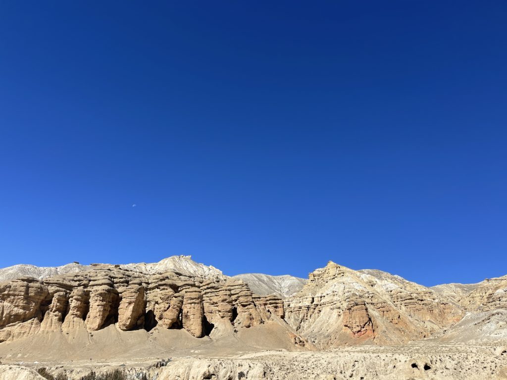
Mooching around Lo Manthang town
Wandering around Lo Manthang is divine. There are no cars, a few motorbikes, a lot of cows and some very friendly locals. There are more shops than I have seen since Pokhara, but they are basically tea houses. I headed out from the hotel the night I arrived and amusingly felt like I knew all the tourists – we had been criss crossing for days. I had a cup of excellent cup of coffee with Matt the Aussie motorcyclist at the lotus coffee house which has a magical cimbali machine. While there are clearly tourists here, and I am sure there are Nepali day trippers that arrive daily, this place is magical and unspoilt.
I had an excellent hot shower, updated my blog and had a cup of tea in the bar where the signal was better. Then an early night.


Excursion to Chhoser – 13km – to see zhong caves and nyiphu gompa
The plan for the first chilling day in Lo Manthang was a 20km circular walk around Namgyal, Thinkar, Namdo, Chhoser and back to Lo. Santos and I set out and were accompanied by the lovely hotel dog. We bashed out a wonderful 12km, arriving in Chhoser in 2.5 hours.
I was definitely feeling the groove – I put some music on and was rocking along to Jimmy Barnes dancing and hiking and trying not to sing. I didn’t notice the two ladies in the field but they were most amused – by the singing and the shorts. (Several ladies have enquired about whether I was cold in my shorts).
The hotel dog by this time had followed us 12km. We stopped to visit the Garpa monastery which had some lovely paintings. And then we went to the Nyphy Gompa (monastery) with its distinctive stripes built into the side of the mountain. It was a lovely wee monastery and I was in time for meditation chanting, which I enjoyed for about 5 minutes before I was meditated out.
Next stop the Zhong cave – a nine story cave monastery. The Nepali ladders were quite the challenge to navigate until I was told you were supposed to ascend them like normal ladders and descend them like stairs.
I ran into Matt, Raj, Santosh, Buddha and Akesh in the cave monastery. They were heading up to the Kora La pass to see the Chinese border and Matt graciously offered to give me a ride on the back of his bike. Never one to say no to an adventure, I accepted. (Yes Mum, I borrowed a helmet, and Matt is an excellent motor cycle rider). Santosh (my guide) was happy to find his own way back to Lo Manthang.
We had a break for a slow lunch of rice and Dahl and then headed off. The road was amusingly bumpy and I had wetter feet than from hiking as we forded a nice cold stream. Sadly the Nepali police were not as enthusiastic about my impromptu adventure as I was. They decided last week to stop letting tourists go up to Kora la. Bummer. Oh well, Santosh, Buddha and Akesh went to the border and Matt and I retreated to Lo Manthang for more coffee. It was quite nice bumping along on the back of the bike back to Lo (feeling slightly guilty about the universal trekker disdain for motorcyclists) – you get the views and the fresh air without having to sweat. But I will be back on my two legs tomorrow.


I had another stroll around the Lo Manthang metropolis – the light is lovely. And then I retreated to the hotel for a busy evening. My french buddies – Frederic, Michelle and Pierre – who I had been meeting on the trail since the beginning and had nicknamed me the ‘melanie express’ joined me in the fancy hotel for a beer (and the use of some upright porcelain, which is hard to find in the Mustang). I then had a lovely dinner with Matt which turned into a broad ranging discussion on indigenous rights, how to be happy, and what I should be doing with my career.
Random meander to take a picture – a three hour 12km hike
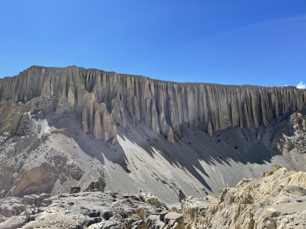
I saw a lovely canyon with white cliffs on the way back from chhoser yesterday and guessed where it was on the map last night, planning to visit it for a photo today. After another hearty fry up and two lattes, I headed out and up the dirt road towards chhoser. After a hefty grunt up hill, it was obvious I was heading in the wrong direction, but I did get to take some photos of the ruins of the old winter castle. I found a trail heading down, and found a suspension bridge which got me back towards Lo Manthang.
Neither alltrails, maps.me or gaia had any tracks heading towards the canyon where I wanted to go, but I could make out a bit of a trail heading along the river, so off I went. I figured I would go as far as I could and see what happened. I dead-ended myself a few times by climbing up too high above the stream and then I would get stuck at a landslide and have to back track. But after about an hour I made it to the junction of the stream and the Kandaki Gali river with an amazing red gorge. Unfortunately I was now too low to take the photo of the white cliffs, but it was stunning nonetheless. I got as far as I could go without fording the river (a ford was possible but cold) and decided to backtrack again. Still wanting a photo of the white cliffs I scrambled 70m up the hill alongside an old stone fence and found my way barred by an enormous barbed wire fence which went a few km in each direction. I followed the fence line to take the photo and then turned around and followed the fence, then an irrigation channel, and then a few stone fences until I eventually came to a road and made it back to town. It turned into a 3 hour 12km outing, but was quite entertaining.


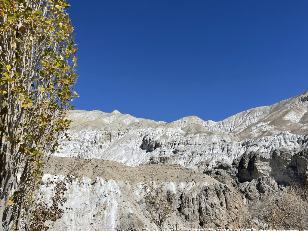
The afternoon was spent drinking coffee in Lo’s cafes and enjoying tea and the sun in the lobby of the Royal Mustang Resort. This hotel is a delight, the staff are wonderful, the rooms are glorious, and it turns out that the lovely man I have been chatting to on reception is actually the owner and crown prince of Lo Manthang. And then I had supper with Magdalena who is also hiking solo.

Stage 5 to Yara
Stage 5 – Lo Manthang to Yara (16km) with a loop walk to Luri Gomba (extra 10km), 26km in total, 1310m ascent, 7h 10m of walking time
After another hearty breakfast, two lattes, and being bestowed with a scarf by the lovely staff, I farewelled the wonderful Royal Mustang Resort and headed up the road to Yara. The first couple of km were along the road and I was irritated to see a jeep full of Nepalis pass by and throw rubbish out the window.
But we swiftly departed the road and took a lovely trail to Dhi. I caught up with a British guy and his guide and porter and we chatted away and moved ahead. We inadvertently took a higher route on the way to Dhi – with better views and a summit on Dadunkha, but with a short section of exposed sandy ridge with steep drops which my new British friend crabbed down (hands and feet down on the ground butt first). It was a bit scary but worth it for the views.


The descent into Dhi was steep. Some sections were sandy and easy. Some sections were gravelly – where the gravel is like ball bearings. I took a tumble at one point, skidding down the slope and got a nice bruise on my butt (its so good, i took a photo but decided i shouldn’t post butt photos on my blog). We arrived in Dhi after three hours and found a tea house for a masala chai. Then headed over the suspension bridge, up the river bed and the finally up a spectacular set of stairs to reach the village of Yara at 12.15.


Santosh had briefed me the prior evening that we would visit Luri Gompa that afternoon (a further 9-10km circuit from Yara). He started making noises over lunch that the gompa would be closed and it wasn’t on the itinerary for the day so we shouldn’t go. I called BS, and he confessed he was too tired to walk up there. So I went by myself. It was a lovely 10km stroll up the Kali Gandaki river bed to the Gompa through stunning rock formations. The gompa was closed but was still lovely from outside. I then wandered back to Yara via the village of Ghara and a steep slide down a gully wall and another riverbed. Divine.


I was hungry when I got back, and had a cheeky dehydrated meal from my stash (LYO mash and cheese is amazeballs), and drank a litre of lemon honey tea. I watched a movie and then had a quiet supper of veg curry and chapatis with an apple pancake. I was pretty warm in my sleeping bag and went to sleep early and was woken up bright and early by village dog barking

Stage 6 to Tangge
Stage 6 – Yara to Tangge 16.3k, 940m ascent, 5h 20m of walking
We set off from Yara at rush hour – with two Germans, and the solo brit ahead of us and the German and French trios behind us. It was a lovely morning and the light was on the distinctive cliffs of Yara so it was a good excuse to stop for lots of photos as we grunted up the hill. After 250m of ascent we spent a lovely few km crossing the flat ‘plateau’, which is high above the river beds. The goats were out and I am amazed at how the shepherds manage to get them to do everything with a few whistles.
I overtook all of the other trekkers on the flat and then came to a horrendous gravely, slippy, slidey, scree descent from the plateau to the river bed a few hundred metres below. Some of it was ok, some of it required hands and feet. Not much of it felt stable underfoot. I managed to keep on my feet in spite of skidding multiple times, so was glad not to add to the bruises on my butt.
We crossed the river on the suspension bridge, and there was another short section of narrow slippery path. I was walking along at snails pace and had to laugh when one of the young porters caught up with me and skipped past in his converse carrying a 20kg load.


We stopped at the tea house in the riverbed for tea, and then began the 500m ascent of the day back to the top of the plateau. It was long but lovely and I lost Santosh and Padam pretty swiftly. I am not fast going up hill but I rarely stop, and that does mean I get to the top quicker than most.


From the high point it was a lovely descent down through bizarre dusty rock mounds to another plateau, and then a shorter but still yuck scree slide to the path that leads to Tange. I arrived at 12.30 and Santosh about 30 minutes later. We had French fries and tea, and then I strolled around the village taking photos. It is pretty quiet with many of the locals already having descended down to warmer climes for the winter. Tangge has the biggest chortens in the Mustang


Dinner started off chilly, but we all warmed up as food arrived. It was a potato evening – my neighbours had fries and potato salad, I had potato curry and potato moms. We then had the local ladies come and sing for us, and my guide led a Nepali dance session – which warmed us up even more. Then bedtime at 8pm.

Stage 7 to Chusang
Stage 7 Tangge to Chusang 24k, 1300m ascent, 1700m descent, 7h30m of walking
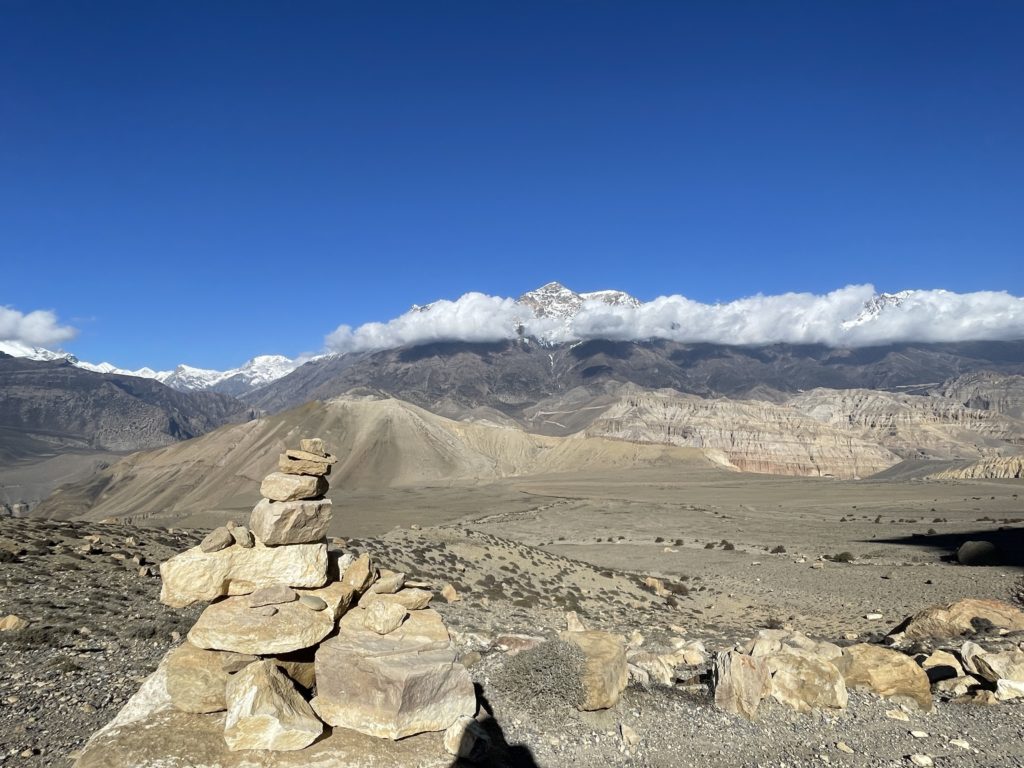
This was my favourite day of the whole trek. Most of us headed out from the guest house at 7am and it was a lovely hike up 900m to the Paa pass at 4183m. Every one took it slow, and I arrived at the top with two of the porters at 9am. From the pass it was a magnificent high route weaving up and down around the 4100m mark with great views across the other side of the valley where we had trekked a few days before en route to Lo Manthang. You could also see the scar in the landscape caused by the road.
I didn’t see any hikers after the pass, just a couple of porters who criss crossed with me when we were taking breaks. They were ahead of their groups and it was quite nice to see them from time to time to know I was on the right track. It was a lovely quiet day, no-one on the trail, no tea houses, no nothing. I stopped at 11 for an early lunch (chapati, boiled egg and apple pancake) and also stopped for tea from the thermos and biscuits a bit later. I had about 20 mins where I had to put all my clothes on as the wind was fierce, but it dropped back to normal and I was fine.


The whole route was 24km, and by 20km I was a bit surprised that we were still at 4100m and I was headed to Chusang at 3000m. Hmmm that is quite a lot of descending to do over not many kms. I passed the two porters taking a break before the descent. The path down was actually mostly ok. The poor weather a few weeks ago meant the path had been muddy and had gotten churned up. Now it had dried solid, but churned up, so easier to grip with the feet. There were a few loose scree areas, I slid about 5 times, and landed on the butt once (annoyingly right on top of the bruise from a few days before). I was almost at Chusang when one of the porters ran down past me – unbelievable as I am walking down super slowly trying not to slide on my arse, and he had 20kg on his back to my 7kg.


I arrived back in Chusang at the Bhrikuti Guest House where we had eaten lunch on our first day. It took me 7.5 hours of un-rushed walking. I rewarded myself with a spring roll and fries, and was delighted to catch up on the news (apparently Liz Truss quit when I was out of signal for three days). It was nice to have a reasonable bathroom, though it hadn’t been cleaned since pre-covid times. The bed was comfy though.

Stage 8 – to Muktinath
Stage 8 Chusang to Muktinath – 16.3k, 1300m of ascent, 4h 25m of walking
Aaah the last day, very sad. We left Chusang at 7.30 and passed the french en route to Tetang. I left Santosh there and mostly managed to navigate to the trail over the next few hours. After an hour and a half I caught up with the German trio and the British guy who gave me a hard time for being speedy. But two of the germans must have decided to follow me to the pass, as they stayed on my tail, and we left the guides and porters behind. We reached the pass after 2.5 hours and they stayed to wait for their group. The views of Nilgiri were stunning, but the wind was cold, so I followed two fast Czech guys down the hill to Muktinath, arriving after about four hours


I decided to head up to the temple at Muktinath. The path up was heaving with slow moving pilgrims and there were a number of pilgrims on mules. The temple is the only one of 108 Divya Desams outside of India. I bathed my hand in each of the 108 streams of water around the temple (though didn’t strip down to shower like the pilgrims). It was interesting after two weeks of tibetan buddhists


I headed to the excellent Bob Marley cafe for lunch. Muktinath ‘town’ was too busy for me, lots of hikers coming off the Annapurna circuit. It was a shock after the laid back vibe of the upper mustang where you feel like you know ever trekker (because you kinda do, especially on the eastern side of the circuit). I had a cappucino and a brownie and waited for the guide. We took a jeep back to Jomsom and I installed myself in the lovely Moksha hotel. Enormous room, loving bathrobe, good sauna, but not very hot water (aaaaah Nepal).


It has been a wonderful ten days trekking….. , I am now planning the Dolpo for 2023,
Jomsom, October 22, 2022

Additional Info
Costs and arranging
First – you need a permit. The govt issue permits for a minimum of two people. You don’t need two people, you just need to pay for two people. (though I suspect some people get around this by piggy backing on other groups). Minimum cost is $50 per day for 10 days. Your local agency will sort this.
Second – you are required to have a guide – that costs $40-50 per day plus $15 per day tip. You can find your own (the whole Hogg link will explain how) or book through an agency. If you aren’t used to carrying 8-10kg of gear (including food and water) you may also want a porter which is another $25 per day plus $10 per day tip.
But if you can stomach the costs, you will get the trip cheaper if you book direct with a Nepali agency. I highly recommend Hidden Trails in Kathmandu who were very flexible on my itinerary. Deducting the permit cost (I paid for two) and the cost of the luxury accommodation in Lo Manthang, I paid USD 3000 for flights, two nice hotel nights in Pokhara, all food and tea house accommodation, a porter and a private guide for 10 days in the Mustang and a day in Pokhara. I am sure you can do it more cheaply – but I thought good value for money for a single person
More excellent detail here https://www.goingthewholehogg.com/upper-mustang-trek-guide/
Route
I encountered numerous tourists who had poor guides who spent their days walking on the road. You do not want to walk on the road. After Samar there are excellent trails on the west side of the valley – there is no need to spend hours on the dusty road. Make sure your guide knows that you do not want to walk on the road.
I would strongly recommend you DO NOT walk from Jomsom to Kagbeni – it is hellishly dusty busy road with buses and jeeps of pilgrims going to Muktinath. Ditto do NOT walk down from Muktinath to Jomsom unless you like traffic and dust. If you are not acclimatised the road walk from Kagbeni to Chele is acceptable. However, if I had already been at altitude I would get a jeep to Samar and start from there.
Also, most trekkers go up and down the same route on the western valley and miss the more logistically difficult and remote eastern return route through Yara and Tangge. The eastern route is the highlight of the circuit there are no roads. My recommended route is on the map below (it is basically what I did, modelled on the excellent mustang trail race). (Note also that the map is poorly formed as Tetang is actually on the route between Kagbeni and Chele so those two points join up)

Staying connected
Wifi is sporadically available in the upper mustang. I bought a good value sim card at the airport for NCell but I should have bought NTC. Don’t buy the sim card in town (apparently they charge usd 30-40), definitely buy it at the airport (Usd 10) from the counters after baggage claim
Amazing pics here https://www.taylorweidman.com/mustang/#/0 and here
You must be logged in to post a comment.