Greenland – the largest island on earth and the most sparsely populated place in the planet. 85% of the land is covered in the ice cap, the population is c 55,000 (largely Inuits), in summer there is no night, and in winter there are no days. Technically it is part of the North American continent, but it is a self ruled territory of Denmark (yes I am ticking off another territory).
The main purpose of the trip is to hike the Arctic Circle trail from Kangerlussuaq to Sisimiut – c. 165km of epic trail through remote wilderness with a few ramshackle free huts available for hikers use and not much else. Apparently there are ferocious mosquitos and pretty challenging weather at the best of times, but this year there have been wildfires blazing for about four weeks, and while the fires aren’t dangerous (peat fires burn low and slow) the smoke can kill you. On top of this, I broke my wrist four weeks ago, and am not 100% sure I can put my tent up without the solid use of my left hand – this is going to be fun!

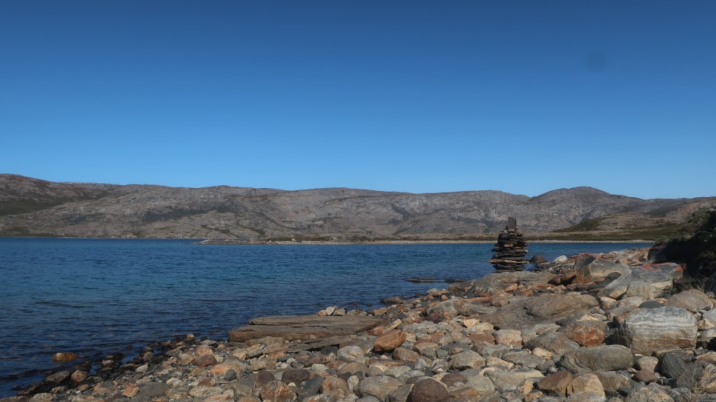
Day 1 – Half day Kangerlussuaq Airport to 3km past Limnaeso Lake (c.25km)
I landed from Copenhagen at lunch time to a lovely clear sunny day. The airport was tiny and not super efficient, so I had time to pop across the road and buy gas, as well as sort out a locker in terminal before my bag arrived on the belt. I loaded up my gear, and hit the road, walking the 13km from the airport to Kellyville along the tarmac, as it is technically part of the trail. I suspect I was one of the few hikers who took the road, as I was overtaken by numerous hikers in taxis in the 2 hours it took to get there. Never mind, I overtook 20 of them pretty swiftly once I hit the trail proper. Once off the road, the landscape was stunning. No trees, but endless lakes and lovely wildflowers…. it was like a sunny Scotland.


I passed the ramshackle collection of caravans and sheds and Hundeso and pushed on to a lovely unnamed lake where I stopped for dinner and a chat with and Aussie hiker, and then given it was still light, I kept strolling until about 8pm where I pitched my tent (pretty wonkily given the wrist disadvantage) in blissful solitude and passed out (once I realised it was actually midnight Denmark time and I had been up since 6am in Denmark)


Day 2 Hiked to 10km past the canoe centre and camped above the beach on lake Kangerluatsiarsuaq (c.45k walking)
I woke up a bit cold as had gone to bed in shorts, not realising that the temperature would drop so much overnight. I was too cold to sleep and too tired and lazy to put more clothes on. It is also pretty awkward sleeping in a sleeping bag with a broken wrist. By 5am I gave in, made breakfast, broke camp and was walking by 5.40am. I passed numerous stunning white Arctic Hares – they obviously think they are camouflaged as they stand stock still when they notice you, thinking you can’t see them (which you couldn’t if it was snowing), but they stand out in the green and red scrub.

It was a stunning morning walk – I passed one tent near the ford at the stunning lake Qarlissuit, but apart from that it was totally still and quiet. After about three hours and 15km I arrived at Katiffik Hut at the head of lake Amitsorsuaq – its a typical Greenlandic hut and I was going to go and take a look but I could see about 20m down the path that one of the occupants had decided to do their morning ablutions 2metres off the trail, and that was more bare butt than I had planned on seeing in the morning, so I kept walking past down to the lake shore where I made myself a coffee and had a second breakfast.


The day heated up as I ambled the 20km down the side of the lake to the canoe centre only passing three people on the way (still packing up their tents at 10am). My feet were getting a bit sore, and I was getting a bit grumpy so I stopped for an hour at 2pm, ate some salami, and soaked my feet in the ice-cold lake. I motivated myself back to action by promising myself an early stop at the lake head in 7km. Unfortunately the lake head wasn’t particularly lovely, it was boggy and windy, so I loaded up with 3 litres of water and planned to dry camp the first nice sheltered place I saw. Unfortunately that nice sheltered place didn’t arrive until about 10km further on at 7.30pm when I had been on my feet for 14 hours and had a sunburnt nose. I tried to pitch my tent around 6.30 at the lake side but it almost blew away. At. 7.30 in the first sheltered spot, I literally pitched my tent one metre from the trail on top of some scrub on a hillside, albeit with a lovely view of Lake Kangerluatsiarsuaq …. with no more mojo to continue, and then started shovelling food in my face for 45 minutes until I konked out.


Day 3 hiked to Innajuattoq and stayed in the lovely hut (c.40km walking)
My sense of humour was somewhat restored after 10 hours sleep, and I woke up at 7am to a lovely view. It was a stunning cool day, just as well as there was a nice 500m climb up from the valley to start the day. The first 2.5 hours to Ikkattooq hut were idyllic, lovely alpine lakes, tonnes of ambling reindeer, impressive views from the plateau, and some rugged cliffs, and then eventually the incongruous hut came into view. A couple of danish doctors were in residence and they shared their hot water with me for my morning coffee and we debated the route. All hikers had been advised to take a southern diversion from the main trail as there was a risk of smoke in the northern valleys. None of us really wanted to do the diversion as there was no trail, limited cairns, and I personally am terrible at navigation. I took some confidence from the fact that they, like me, were planning to go north and see what it was like, and potentially use an escape route if required that someone on the arctic circle Facebook group had mooted.


The next three hours was a bit of a mountain scramble and then a steep descent down to a wide river valley with a ford. Unfortunately, my brain wasn’t turned on, as while I forded the river like a kiwi expert, I forgot that my phone and camera were in the pockets of my shorts, so both were drenched, and neither have worked since – hence the paucity of photos from here on in. oh well! I eventually reached Eqalugaarniarfik Hut around 2pm feeling pretty hot and knackered. The hut was full and surrounded by tents. I met some local girls inside who advised me to go south but told me everyone else had gone north. They were from a children’s home in sisimiut, and were out in the wilderness learning how to hunt reindeer, and they were very proud to show me their gun. They invited me for lunch, but I decided to keep going….., I probably would have stopped for lunch if I had realised there was another big arsed hill to climb straight up from the hut….., it was slow going. I am pretty unfit at the moment, so did have to have a talking to myself half way up ;-).


Once up the hill, the views were stunning and the rest of the path for the afternoon was a pure delight, going around the lakeshore of three beautiful lakes and then following a river valley to Innajuattoq hut. I past three Czech students heading in the other direction to me who assured me the trail was smoke free, and then I passed a trio of guys with enormous 25kg bags (a greenlander, a Parisian and a dane) but more on them later.
I arrived at the Innajuattoq hut at about 6.00, and decided to stay inside for the night. This was widely touted as the best hut on the trail, and the three occupants already in residence were delightful – Theo and Linea from Austria/Netherlands, and Jens from Denmark. I promptly started devouring a four course meal of soup, fish and potatoes and two desserts, a cup of tea and a cup of cocoa, and then started feeling normal, as the trio of guys I had passed earlier arrived. Bo, Brian and Goran…. they were like a comedic trio, with amusing riffs and they entertained us all until 10pm, well past my bed time when I finally called it a night. I slept wonderfully – sleeping inside on a mattress is a heck of a lot easier with a broken wrist even if you do have to put up with gentle danish snoring.


Day 4 hiked to Kangerluarsuk Tullek Hut (short day, 34km walking, finished at 3pm)
I woke up at 6.30 and headed out by 7.00, packing up quietly so as not to wake up my fellow hikers. Most people on this trail take 9-10 days to walk the trail, so don’t start early. They also carry huge bags – with the average weight being c. 20-25kg, compared to my 10-11kg (including all my food).
It was an easy morning 17k hike to Nerumaq hut along a river valley with steep cliffs on either side and a few lovely lakes. I have realised the walking here for me is always easy in the morning when it is cool and the sun is at your back.


I arrived at Nerumak around 10am and make some pasta for an early lunch, had a coffee and then headed further up the valley. This was crunch time as this was the smoke zone. I covered the first 10km without any worries, but then did start seeing the smoke billowing up from a neighbouring valley. Fortunately very little of it was coming my way and I knew I was walking into the wind, so if I made it a few more kms, then I would be fine. I pressed on, but couldn’t help stopping to check out the aftermath of the fire on the far side of the river.
By about 2pm I was through the worst of it and at the lake just before the ford at Kangerluarsuk Tulleq. The worst hiking hours here are in the afternoon with the sun in your face and sweat in your eyes and tired feet. I knew the hut was uphill and it is quite dry at the moment so I couldn’t guarantee there would be water, so I loaded up with 3kg of water and slogged (very slowly) up hill to the hut. I took two wrong turns, as there were very few cairns, had one sense of humour failure, and finally made it to the hut at 3.30pm having done 34km. I could have kept going, but I really couldn’t motivate myself, and I only had 20km to get to sisimiut the day after anyway.


I entertained myself in the hut with Anders the German backpacker, eating more food, while he made do with soup and instant potato (I was nice and gave him some tuna and boiled his water for him), and we watched the smoke billowing from the other side of the ford. Two German ladies arrived a little later, Irena kept me entertained with the weight of the gear in her pack – she had a mattress made of down that weighed 1kg and required a special apparatus to blow it up – it was quite something. It was a tiny hut so we squished in together. I am not normally a fan of huts over my tent, but with the arm busted, it is definitely easier. I was in my sleeping bag by 8pm, and we were all asleep by 8.30pm – a big night in the bush
Day 5 last 22km to Sisimuit (arrived at 11am)
I woke up at 6 thinking the hut was surrounded by fog, but it was actually smoke, so I roused the others, packed up and headed out by 7am (after taking a wrong route for 20 minutes).


The trail sidles along the mountain side next to a fjord and there were stunning views, and then the trail veers sharply up to do a nice steep climb up to Qerrortusup Majoriaa. These high sections are beautiful, lots of little lakes and stunning views. There were a few tents dotted along the route. I met a Belgian guy about half way to Sisimiut who was making breakfast outside his tent at 10am accompanied by a very adorable local husky dog. Apparently she adopts hikers and walks them up and down the trail. Lucky for me, Snowy (as I named her), guided me most of the rest of the route to Sisimiut. Well perhaps not so lucky, as not far from the last descent (perhaps an hour from town), I forded a river, slipped on a boulder and fell hard on my broken wrist, and managed to get a great graze on my knee and as I would find out later, chip off a bit of bone in my little finger, fracture the joint and tear a tendon. Oh well!!!

I made it to Sisimiut just before 11, happy that I completed the trail in less than four days walking time. Less happy that I didn’t have a phone (and therefore didn’t know where my Airbnb was as didn’t have the address and there is no Internet cafe in town) :-). The universe always manages to sort me out, and I stopped in the first hotel I saw, got a map, and directions to the phone shop and the hospital. Sorted myself out an excellent 40 euro smart phone, got some X-rays on my broken finger, ate some pastries, and had a shower. I also had the good luck to meet Bo, Brian and Goran again. They had arrived at Nerumak hut in the evening on the same day I passed and there was a lot of smoke, so they pushed the sos button did the rest of the trail in a helicopter :-), which was nice for me as they were excellent dinner companions in Sisimiut.
Postscript – the Ice cap


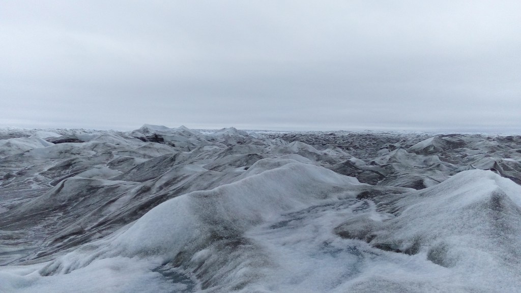
I overnighted in Sisimuit, and then flew back to Kangerlussuaq. My plan had been to take a tour to the icecap and then walk the 40km back to the airport in time to catch my flight out. However, the weather had turned, my little finger was blue and difficult, and I decided to just be lazy and go on the tour and come back in the nice warm bus and stay in the excellent airport hotel. I highly recommend heading out to the icecap – its amazing and the Russell glacier is also lovely
This really was an amazing trail, and we were blessed with fantastic sunny clear weather all day, and unusually no mosquitos. Apart from the fire worries, the weather couldn’t have been better. I loved this trail and would be very happy to do it again!!!
Additional notes
- Trail resources – I would highly recommend Paddy Dillons cicerone guide, the Greenland gps app (free), and the invaluable Facebook group hosted by Jesper and Huw
- Food – take all your food with you, everything will be cheaper in your home country, and it also means you can get walking straight away. Gas and fuel are available in multiple places in Kanger, including the Isusishut which is 15m from the airport door
- Gear – I took more or less what I took on the kungsleden (list here) except I took a poncho instead of waterproof pants and a jacket; and I now have a lighter mini in reach (highly recommended). I also took an extra fleece for the evenings and my heavier sleeping back (an extra 1kg in total max)
- Tour – I booked with https://aac.gl to go to the icecap
Kangerlussuaq, August 16, 2019
You must be logged in to post a comment.